I was in Denver last week for a few mapping and programming conferences that might be of interest to those following Farming Concrete.
One of these was State of the Map, the annual meetup for the community behind OpenStreetMap (OSM), the collaborative (wiki-esque) map of the world. I’ve been a part of the project for a few years, and much of the philosophy behind Farming Concrete–open data collection and collaboration using the internet–is inspired by OSM and similar projects. Talks ranged from collecting data (eg, using Walking Papers) to outputting this data (eg, into Pretty Maps) to mini, rapid-fire talks on the state of the map in various countries (eg, the UK, Tunisia, Haiti, Georgia, and the Phillipines).
One attendee talked about the Mushroom Development Foundation, an NGO in northeast India that is helping farmers grow mushrooms because they can be grown more densely than most crops and are therefore more valuable than other crops. The speaker roughly detailed a scheme for mapping farms, which are organized in clusters of 80-180 around 10+ central villages. The foundation’s plan was to use the map to ease the difficulty of working with many hundreds of farms, specifically the logistics of getting the required inputs to farmers. Unfortunately, there wasn’t any mention of mapping mushroom yield, but maybe that will happen once the farms are mapped!
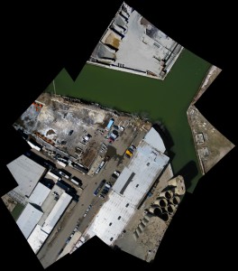
My favorite session revolved around a method of research that is often called citizen science. The basis of this method is the democratization of scientific research by including community members and amateur scientists. Speakers included representatives of Public Laboratory and Grassroots Jerusalem, and Muki Haklay. Public Laboratory has been doing some awesome work with hardware and software to make it easier for people to collect many kinds of data. In the context of State of the Map their focus was on cheaply creating aerial photographic maps using kites and balloons.

This technique has been used perhaps most famously to map the spread of oil in the Gulf of Mexico during and after the Deepwater Horizon catastrophe. Similarly, on the ground, Grassroots Jerusalem has been mapping Jerusalem in a collaborative and inclusive way.

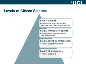
Mr. Haklay’s talk was a critique of citizen science that is summarized by Public Laboratory above: “much of so-called citizen science treats people like mere data points.” At what point are researchers using so-called citizen scientists and at what point are the citizen scientists driving the research? To what degree are the citizen scientists taking part in the definition of the problem being researched, the data collection, and the analysis of the data? Surely all citizen science projects vary by degrees of inclusiveness for each of these dimensions, so Muki introduced the term extreme citizen science to denote those projects which strongly include non-scientists in all three dimensions. I’m not a big fan of adding “extreme” to anything, but I do find these levels useful:

Where does Farming Concrete land on this scale? What could we be doing better?
When it comes to data analysis I think we have done a good job of giving gardens and gardeners the data that they recorded. We do not accept any data that we do not return to gardeners. This way gardeners can look at how their numbers line up with other gardeners, both within their gardens and with gardens citywide. Gardeners can then use this data when defending their land, fundraising, or for whatever reason they see fit.
The problem definition part of the research seems less favorable since Farming Concrete was started solely to estimate the amount of food grown in NYC’s community gardens. However, the problem has evolved through conversations with other gardeners since the project’s inception. This year, after a number of passionate school gardeners contacted us we decided to include school gardens in our survey. Last year and this, some gardeners weighed things other than plant yield such as honey and compost. While we don’t have enough data from other gardens to give these gardeners a citywide context, we’re ecstatic that providing scales and a technical structure for recording weights has led to people weighing what’s important to them.
Finally, we’re utterly dependent on gardeners collecting the data that we use in our analysis. We know that it can range from tedious to impossible sometimes, but from our perspective asking gardeners to weigh their own produce if they want to is far less invasive and much more sensible than sending teams of researchers to gardens to do this.
Otherwise, I had many fun conversations and learned so much about open source map technology that should help Farming Concrete, but I won’t bother you with that yet.
