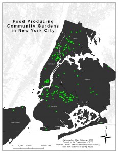
I figured this was a good topic to start with, since there is so much going on in terms of food systems mapping and urban agriculture in NYC. It really is incredible how many people are currently researching the local urban food system. Let’s do more.
Here’s a running list of who knows what:
GrowNYC (formally Council on the Environment of NYC) – Maintains the database of all of the community gardens in the city (which I am in the process of updating). This includes gardens from GreenThumb, New York Restoration Project (NYRP), Trust for Public Land, and Brooklyn GreenBridge (program of the Brooklyn Botanic Garden). They use this database to update the Community Garden layer on OASIS.
OASIS (Open Accessible Space Information System) – A project in collaboration with dozens of grassroots organizations, city agencies, and non-profits, currently housed at the CUNY Graduate Center, OASIS maintains publicly accessible maps of data about the city in one cohesive, interactive space. It is used by planners, council members, community boards, academics, organizations, etc. to make thousands of maps annually. For our purposes, this serves to put aspects of the food system in some sort of context. You can find community gardens and farmers’ markets, but you can also find census data, parks, schools, and more. Link to the new website here.
New York City Coalition Against Hunger (NYCCAH) – “The New York City Coalition Against Hunger (NYCCAH) represents the more than 1,200 nonprofit soup kitchens and food pantries in New York City and the more than 1.3 million low-income New Yorkers who are forced to use them,” with a goal of self-sufficiency. They have mapped soup kitchens, food pantries, summer food programs, and more.
Just Food – Battles food inaccessibility by promoting urban connections to local food. They keep the most up-to-date records of the city’s CSAs, and they are working on mapping NYC’s city farms.
NYC Department of City Planning – As part of their FRESH (Food Retail Expansion to Support Health) initiative, DCP has done extensive research on supermarket need using an index of food retail locations and census data.
New York State Department of Agriculture and Markets – beginning the process of creating a database of community gardens in NY State and school gardens in NYC.
Please email me if you see something missing – mara (at) farmingconcrete (dot) com
There’s also the Five Borough Farm project of the Design Trust for Public Space.
http://www.designtrust.org/projects/project_09farm.html